 |
 |
 |
 |
 |
 |
 |
 |
 |
 |
 |
 |
 |
![]()
Abflug Bremen Airport 0600, Ankunft Luqa International Airport Malta 0930 mit Boeing 737, Ryanair. Mietwagen von Hertz, Unterkunft in Mellieha, Riviera Hotel und Spa.
Abflug Luqa International Airport Malta 1100, Ankunft Bremen Airport 1330
![]()
Take-off Bremen airport 0600, arrival Luqa, International airport Malta 0930 with Boeing 737, Ryanair. Hire car of hertz, accommodation in Mellieha, Riviera hotel and Spa.
Take-off Luqa International airport Malta 1100, arrival Bremen airport 1330
 |  |
| Riviera Hotel and Spa Mellieha | dto. |
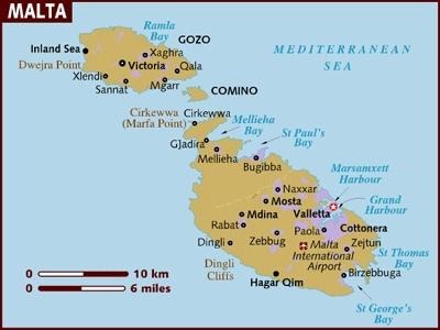
z.B. Malta - Mittelmeerinsel mit bewegter Vergangenheit.
Die Republik Malta umfasst die Inseln Malta, Gozo und Comino mit einer Gesamtfläche von 315,6 qkm. Malta selbst hat etwa 1/4 der Fläche von Berlin. Die Bevölkerungszahl beträgt ca. 400 000, davon sind 91% Katholiken. Das Bruttosozialprodukt Maltas beträgt ca. 4,10 Mrd € in 2006, davon entfallen auf die Landwirtschaft 2%, auf die Industrie 26%, auf den Tourismus ca. 51%.
![]()
e.g. Malta, middle sea island with a busy past.
The Republic of Malta surrounds the islands of Malta, Gozo and Comino with a total area of 315.6 qkm. About 1/4 of the area of Berlin has Malta itself. Approx. 400 000 is the total population, of this 91% Roman Catholics are. The gross national product of Malta amounts to approx. 4.10 bn € in 2006, of this 2% are allotted to the farming on the industry 26% on the tourism approx. 51%.
Der Süden Maltas - Steinzeittempel und Fischeridylle
Im Südosten der Insel Malta, eingefasst vom Grand Harbour und der Marsaxlokk Bay, erstreckt sich eine leicht gewellte Hügellandschaft. Auf weiten Flächen sieht man fruchtbare Terra-Rossa-Böden. Die typische rote Malta-Erde bildet sich aus der Verwitterung des Kalkgesteins, aus dem sich die Insel geologisch aufbaut. Von Norden her steigt das Land sanft zum Plateau zwischen Zabbar, Zejtun und Ghaxaq an. Bei Zurrieq im Süden hat es dann genug an Höhe gewonnen, um über gut 100 Meter als Steilküste wieder ins Meer abzufallen. Bis auf Paola, das noch zum urbanen Gürtel rund um Valletta zu rechnen ist, liegen die Orte relativ geschlossen inmitten von Feldern - es sind eher beschauliche Landstädtchen, in denen die Traditionen auch heute noch zählen. Kirchen prägen das Landschaftsbild, das ansonsten im Wesentlichen durch die Bruchsteinmauern geprägt ist, die überall auf Malta die kargen Felder einfassen.
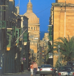 | 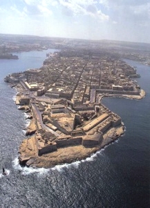 | ||||
| The Streets of La Valletta | Fort St. Elmo / La Valletta |
![]()
The south of Malta, Stone Age temple and fisherman idyll
An easily corrugated hill landscape extends in the southeast of the island of Malta edged by the grand Harbour and the Marsaxlokk Bay. One sees fertile Terra-Rossa floors on wide areas. The typical red Malta earth forms from the weathering of the lime rock of which the island geologically builds up. The country rises gently from the north to the plateau between Zabbar, Zejtun and Ghaxaq. It then has won at height at Zurrieq in the south enough to fall more than more than 100 meters as a steep coast into the sea again. This except for Paola still to the urban belt around Valletta there is a good chance, the places relatively closed lie amongst countries -- it is rather quiet country small towns, in these the traditions counts also today certainly. Churches emboss the view which is otherwise marked essentially by the rough walls which edge the meager fields everywhere in Malta.
Zentral-Malta - aus dem Trubel in die Stille
Zwei ganz unterschiedliche Gesichter prägen den mittleren Teil der Insel Malta, sowohl landschaftlich als auch was die Bevölkerungsdichte angeht. Das Hügelland, das von Norden her sanft ansteigt, geht im Süden über eine deutliche Bruchstufe in das Hochland rund um die alte Inselhauptstadt Mdina über, wo bis zu 280 Meter über dem Meer erreicht werden. Hier finden sich weite unfruchtbare Geröllflächen. Dagegen ist die Tiefebene ein Gebiet aus Globigerinenkalk und fruchtbarer, zumal das Hochland eine Art natürlichen Wasserturm darstellt. Zwischen Mdina und dem Siedlungsgürtel um Valletta erstrecken sich daher große Felder, die zudem weniger von den sonst üblichen Steinmauern zerschnitten sind als im übrigen Malta. Noch krasser sind die Unterschiede in siedlungsstruktureller Hinsicht. An der Nordküste, von den Toren Vallettas bis hin nach San Giljan, breitet sich ein fast unüberschaubares Häusermeer aus; hier grenzen dicht bevölkerte Orte so eng aneinander, dass die meisten Fremden rasch jede Orientierung verlieren. Erst hinter Birkirkara und den Three Villages, wie die Malteser die miteinander verschmolzenen Dörfer Attard, lija und Balzan zu nennen pflegen, wird es ruhiger.
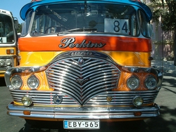 | 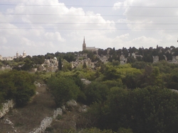 |
| Bus 84 La Valletta | Adolorata Cemetery |
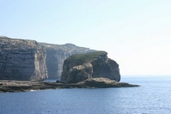 | 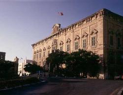 |
| Mushroom Rock Malta | Auberge de Castille et Leon |
![]()
Central Malta from the hurly-burly into the silence
Two quite different faces characterize the middle part of the island of Malta, both scenic and what tackle the population density. The hilly country which gently rises from the north changes into the highland around the old island capital Mdina over a clear break stage in the south, where meters are reached over the sea up to 280. Wide barren rubble areas are found here. Against this the lowland plain is from Globigerinenkalk and more fertilely an area particularly since this represents highland a kind of natural water-tower. Therefore big countries which moreover are cut by the otherwise usual stone walls less than in other Malta extend between Mdina and the settlement belt around Valletta. The differences are even more glaring in settlement structural regard. An almost incalculable house sea spreads at the northern coast from the gates Vallettas to to to San Giljan; here densely populated places border so narrowly on each other that most foreign parts lose every orientation quickly. First behind Birkirkara and the Three Villagess as the Malteses use to call the villages of Attard, lija and Balzan merged with each other becomes as well it.
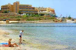
Der Nordwesten Maltas - Strandparadiese und Bauernland
Das zentrale Hügelland Maltas wird durch eine ausgeprägte Bruchstufe nach Nordwesten begrenzt: Die Great Fault entspricht in etwa der Linie vom Madliena Tower über Mosta bis zur Fomm ir-Rih Bay. Dahinter befindet sich eine ganz anders geformte Landschaft. Im Wechsel lösen sich jeweils 5 von NO nach SW streichende Senken mit parallel verlaufenden Höhenrücken ab. Während an den langen Berghängen vor allem des Wardija Ridge und des Bajda Ridge Terrassenfeldbau betrieben wird, sind die Agrarflächen in den Talfurchen besonders fruchtbar, weil hier der Grundwasserspiegel leicht für eine künstliche Bewässerung zu benutzen ist. Bis heute gehören Windräder zum Landschaftsbild. Da die Talschnitte sich jeweils in weiten Buchten zum Meer öffnen, liegen in diesem Landesteil auch die schönsten Strände.
Doch was den Besucher von heute freut, war im piratengefährdeten Mittelalter ein Fluch: Die Buchten luden Plünderer geradezu zur Landung ein. So wurden zu dieser Zeit alle Siedlungen aus der Antike - vor allem unter den Römern baute man hier Oliven und Weizen an - aufgegeben. Die Bevölkerung zog sich hinter die leichter zu verteidigende Great Fault zurück. Ihre Rolle als Abwehrwall spielte diese Höhenlinie, die die Briten Mitte des 19. Jh. mit den Forts und Geschützstellungen der Victoria Lines sicherten, bis zum zweiten Weltkrieg, als hier zusätzliche Betonunterstände angelegt wurden. Sieht man von der Touristenstadt Bugibba einmal ab, ist die Bevölkerungsdichte im NW Maltas noch immer relativ gering.
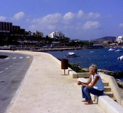 |  |
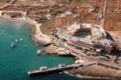
| St. Pauls Bay | Mellieha |
 |  |
| Car Ferry to Gozo | Mellieha Bay |
![]()
The northwest of Malta, beach paradises and farmer country
The central hilly country of Malta is limited by a distinctive break stage to the northwest: Greatly rots the corresponds approximately to the line of the Madliena control tower about Mosta up to the Fomm ir Rih Bay. A quite differently formed landscape is behind it. In the change 5 valleys each painting of no according to SW take themselves off with height backs going parallel. While primarily the Wardija Ridge's and the Bajda Ridge's terrace cultivation of the fields is done at the long mountain slopes, the agricultural areas are particularly fertile in the valley furrows because the ground-water level has to be used for an artificial irrigation here easily. Wind turbines are part of the view to this day. Since the valley cuts open respectively in wide bays to the sea the most beautiful beaches are also located in this region.
But what pleases the visitor of today was a curse in the pirate endangered Middle Ages: The bays invited looters to the landing virtually. So all settlements turned -- at that time from the antiquity one primarily cultivated olives and wheat under the romans here, given up. The population retired more easily defending Greatly rots back behind this one. Your role as a defense embankment played this height line up to the second World War which the brits secured for lines with the Forts and gun emplacements of Victoria in the middle of the 19th century when additional concrete shelters were laid out here. If one refrains from the tourist city of Bugibba once, the population density is still low in the NW Maltas relatively.